Watershed Assessments
A watershed assessment refers to a comprehensive evaluation of a watershed to manage hydrologic and geomorphic risks. It involves understanding and analyzing the various processes, physical characteristics, and the current condition of a watershed. This includes recognizing sensitive areas, past disturbances, and how the watershed might respond to future disturbances or management actions. Many field and desktop-based assessment procedures focus on the state and functioning condition of a watershed.
Key Objectives of a Watershed Assessment:
Key objectives of a watershed assessment generally include one or more of the following components...
- Incorporation of Values and Knowledge: Recognizing the unique legal and cultural relationships of First Nations with the land. Direct dialogue, leadership, and input from First Nations communities is used to help refine values and priorities. Early engagement with First Nations, local communities, and various stakeholders is paramount to integrate knowledge and values into the assessment process, especially regarding local fisheries.
- Understanding Watershed Processes and Characteristics: This includes analyzing and characterizing physical aspects like geology, hydrology, and ecology of the watershed. For example, developing a conceptual (semi-quantitative) or fully quantitative model to understand runoff, interception, groundwater and surface water flow at critical periods. This process also includes an assessment of fish habitat, fish periodicity, and connectivity.
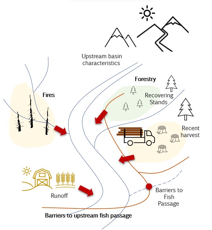
- Assess Cumulative Impacts of Human Activities: The assessment examines how human development activities, such as land alteration, forestry, agriculture and urbanization, collectively impact natural hydrological processes. These activities may exacerbate peak flows, cause surface erosion, affect riparian zones, and potentially trigger mass wasting events. Other activities may increase rates of evapotranspiration reducing stream flow during critical low-flow periods, reduce connectivity/fish-passage and/or influence water quality.
- Develop Indicators and Benchmarks: Quantitative indicators are often developed to support status assessments. These indicators may be linked to condition thresholds or benchmarks specified per-defined for a specific program, location, etc. that conditions underlying watershed processes, human activities, evaluation end points and the geographic context. Generally, benchmarks and indicators are developed by working backwards from an initial values assessment (e.g., fish habitat and corresponding watershed sensitivities).
- Defining and Setting Future Objectives: Defining specific goals for the condition of the watershed and the values it should uphold, such as biodiversity, water quality, water quantity, connectivity, and riparian health.
- (Support) Decision-Making: Employing a defensible process to balance risks and benefits, considering the impacts of overlapping development activities.
- Strategy Selection: Choosing appropriate management strategies and actions to meet the set objectives. Management decisions should work towards achieving goals and benchmarks defined in previous steps, exploring alternative options and defining actions to monitor progress and avenues to adapt to novel insights.
- Monitoring and Revision: Continuous monitoring of the watershed to assess the effectiveness of implemented measures and make necessary adjustments. For example, GIS-based indicators and thresholds should be continually critiqued, updated, and refined with field data.
- Periodic Re-examination: Regularly re-evaluating the watershed's condition to ensure alignment with long-term objectives.
TOOLS, CODEBASES, AND FRAMEWORKS:
- Pacific Salmon Foundation - Pacific Salmon Explorer.
- BC-CEF Watershed Hazard Assessment - Regional Watershed Assessments.
- BC Water Tools (Foundry Spatial): https://www.bcwatertool.ca/
Key References and Case Studies:
Summary of GIS Tier 1 Indicators and Benchmarks (Excel Workbook)
- CWAP/IWAP (1999): B.C. Ministry of Forests. 2001. Watershed assessment procedure guidebook. 2nd ed., Version 2.1. For. Prac. Br., Min. For., Victoria, B.C. Forest Practices Code of British Columbia Guidebook.
- Pike and Wilford (2013): Pike, R.G. and D.J. Wilford. 2003. Desktop watershed characterization methods for British Columbia. Prov. B.C., Victoria, B.C. Tech. Rep. 079.
- WSEP (2013 - 2019): Porter, M., S. Casley, Darcy Pickard, E. Snead, R. Smith, and K. Wieckowski. 2017. Version 3.4, March 2019. Watershed Status Evaluation Protocol (WSEP): Tier 1 – watershed-level fish values monitoring. Report prepared by ESSA Technologies Ltd. for BC British Columbia Ministry of Forests, Lands and Natural Resource Operations and BC Ministry of the Environment (MOE), Victoria, BC. 27 p.
- WHPOR (2015): Watershed Health Project Omineca (multiple references, see Lewis et al. 2016).
- FREP #39 FSW (2015): M. Porter, S. Casley, N. Ochoski, and S. Huang. 2015. Watershed Status Evaluation: An Assessment of 71 Watersheds Meeting BC's Fisheries Sensitive Watershed Criteria. Victoria BC FREP Report 39.
- Lewis et al. (2016): Lewis, D., Grainger, B. & Milne, M. (2016). A GIS Indicator-Based Watershed Assessment Procedure for Assessing Cumulative Watershed Effects. 31pp.
- FSW Objectives (2017): Provincial Fisheries Sensitive Watershed Procedures Working Group. 2017. Fisheries Sensitive Watershed Default objectives and Designation Procedure. Ministry of Forests, Lands, and Natural Resource Operations and Rural Development. Victoria, BC. / WET (Watershed Evaluation Tool).
- BC-CEF IAP (2020): Interim Assessment Protocol for Aquatic Ecosystems in British Columbia – Standards for Assessing the Condition of Aquatic Ecosystems under British Columbia’s Cumulative Effects Framework. Version 1.3 (December 2020). Prepared by the Provincial Aquatic Ecosystems Technical Working Group – Ministry of Environment and Climate Change Strategy and Ministry of Forests, Lands and Natural Resource Operations and Rural Development. 51 pp.
- Engineers and Geoscientists of BC (2020). Watershed Assessment and Management of Hydrologic and Geomorphic Risk in Forest Sector. Version 1.0, January 14, 2020 ©2020 Engineers and Geoscientists British Columbia and Association of British Columbia Forest Professionals.

